Daedalus Reef
Virtual asset linked to this landmark

- Virtual owner
- The platform
- Times sold
- 0
- Fame on Wikipedia
- 3,526 article reads in 12 months
- Searches (30 days)
- 0
- Watching
- 0
Virtual ownership only. It gives no legal, financial or physical right in the real landmark. Prices are set by the market and may fall.
About Daedalus Reef and its history
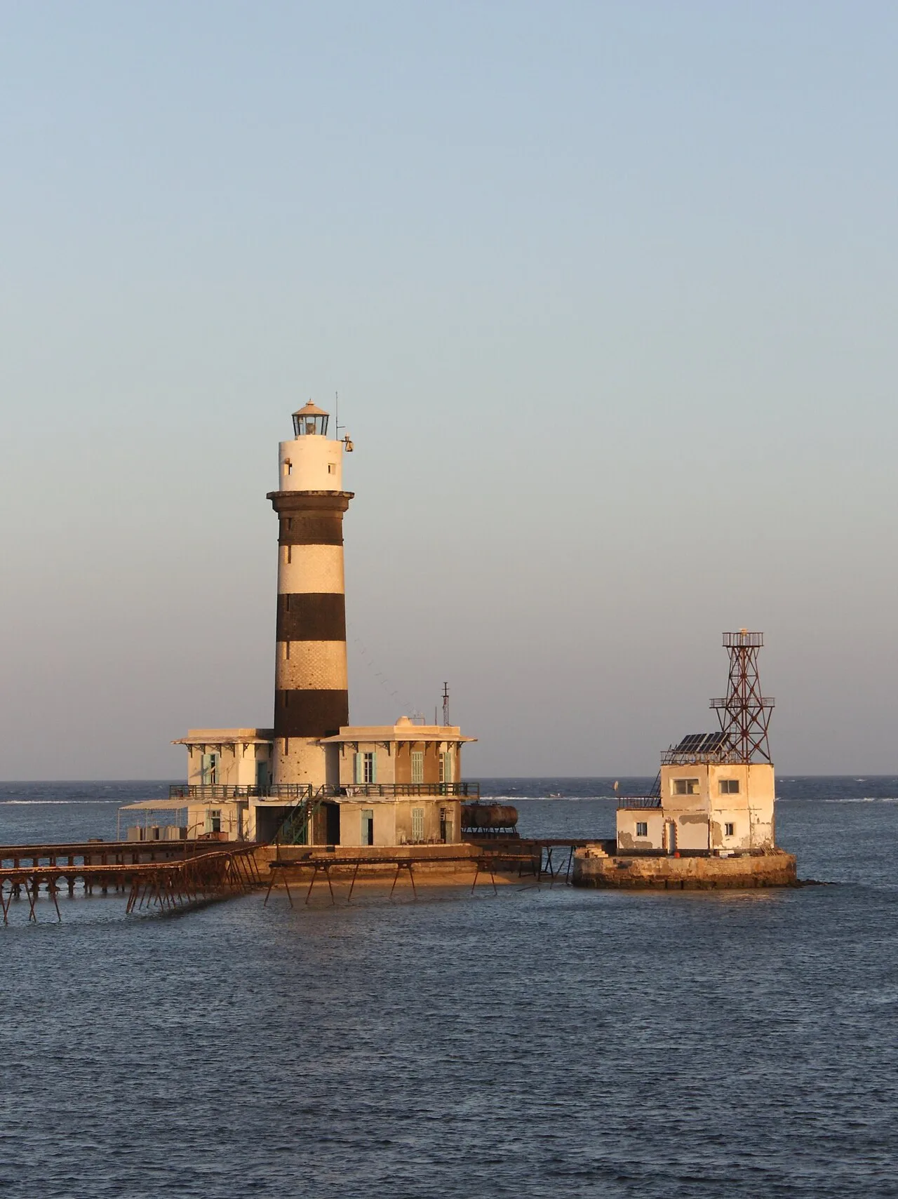
An isolated reef in the open Red Sea tens of kilometres off Marsa Alam, topped by a nineteenth-century lighthouse.
Daedalus Reef (Arabic: أبو قيزان, romanized: Abu Kizan) is an isolated oceanic coral reef in the Egyptian Red Sea, located approximately 90 kilometres (56 mi) east of Marsa Alam and about 100 kilometres (62 mi) south-east of Hurghada, at coordinates 24°55′24″N 35°51′30″E. The reef rises from a water depth of approximately 550 metres (1,800 ft) and its surface platform measures roughly 1,075 metres (3,527 ft) in length by 300 metres (984 ft) in width, bordered on all sides by near-vertical walls with dense coral growth. At its northern tip stands the operational Daedalus Reef Lighthouse, first constructed in 1863 and rebuilt in 1931.
The reef is part of Egypt's Red Sea marine protected area network, governed by a legal framework founded on Law No. 102 of 1983 and most recently reinforced by Prime Minister's Decree No. 4419 of 2025, which designated the entire Great Fringing Reef of the Red Sea as a marine protected area. Daedalus Reef is internationally recognised for its pelagic marine biodiversity and is considered one of the premier shark-observation sites in the Red Sea, with up to eight species documented through systematic underwater surveys.
Geography, navigation and cartography
Daedalus Reef lies in the offshore Egyptian Red Sea, well beyond the continental coastline of the Red Sea Governorate, making it one of the most remote navigational landmarks in the southern Red Sea shipping lanes. Its oceanic isolation, combined with exposure to prevailing Red Sea currents, defines both its ecological character and its significance as a navigational hazard.
The reef is recorded in the official navigation registers of the United Kingdom Hydrographic Office (UKHO) under the identifier Admiralty D7296 (also referenced as D7296.1, formerly E6048), and in the United States National Geospatial-Intelligence Agency (NGA) register as NGA 30492. These designations constitute the canonical international references for the lighthouse marking the reef and are the identifiers used in the mandatory aids-to-navigation publications for professional seafarers.
The reef platform rises from a seabed at approximately 550 m (1,800 ft) depth. Its surface measures approximately 1,075 m × 300 m (3,527 ft × 984 ft), with edges that drop in sheer walls and steep slopes. The interaction between its bathymetry, open-ocean exposure and upwelling currents accounts for both its exceptional ecological productivity and its reputation among technical and recreational divers.
Source: Wikipedia · text available under CC BY-SA 4.0
- Location
- Marsa Alam, Egypt
- Coordinates
- 24.9242, 35.8619
- Category
- Nature & Parks
Source: Wikipedia · Factual information about the real landmark; unrelated to virtual ownership.