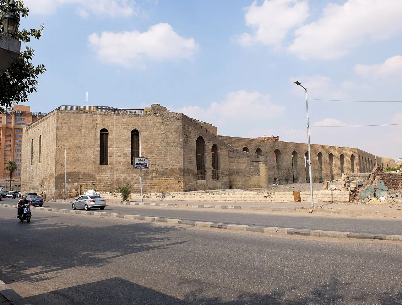
Cairo Citadel Aqueduct
Virtual asset linked to this landmark

- Virtual owner
- The platform
- Times sold
- 0
- Fame on Wikipedia
- 4,532 article reads in 12 months
- Searches (30 days)
- 0
- Watching
- 0
Virtual ownership only. It gives no legal, financial or physical right in the real landmark. Prices are set by the market and may fall.
About Cairo Citadel Aqueduct and its history
An old aqueduct that carried Nile water to the Cairo Citadel.
The Cairo Citadel Aqueduct or Mamluk Aqueduct (Arabic: سور مجرى العيون, romanized: sūr magra al-ʿayyūn) is a medieval aqueduct system in Cairo, Egypt. It was first conceived and built during the Ayyubid period (under Salah ad-Din and his successors) but was later reworked by several Mamluk sultans to expand the provision of water to the Citadel of Cairo. Although no longer functioning today, much of the aqueduct structure, including its water intake tower, the Fumm al-Khalig, still stands.
The Citadel of Cairo was a massive fortified complex and royal residence begun by Salah ad-Din (Saladin) in 1176 and most likely finished by al-Kamil at the beginning of the 13th century. The Citadel was the centerpiece of a new extensive defensive system for Cairo which included building a long wall around both Cairo and the older city of Fustat and connecting it to the Citadel. Salah ad-Din, or one of his Ayyubid successors, also developed the idea of bringing water from the Nile to the Citadel by building a canal along the top of this wall. The aqueduct started from the wall's western end near Fustat (at the shore of the Nile), where water was raised through a series of waterwheels, and ran from there to the Citadel. This project was likely carried out or finished by al-Kamil (even though the full course of the defensive wall Salah ad-Din had envisioned was never fully finished). This aqueduct system was built in addition to the famous Spiral Well built by Salah ad-Din (also known as the Bi'r Yusuf) inside the Citadel, which could provide water in times of siege in case the aqueduct was cut off.
During the Mamluk period, the Citadel was further developed by successive sultans into an even more elaborate complex, with more ambitious buildings. In particular, under Sultan al-Nasir Muhammad in the early 14th century the Citadel was expanded and several important palaces and monuments were built within and around it. In 1311 or 1312, al-Nasir Muhammad ordered the renovation and improvement of the Citadel's aqueduct. His predecessor and brother, Sultan al-Ashraf Khalil, was likely responsible for having already built the water intake tower but was likely killed before he could do more. Al-Nasir completed the project.
The intake tower was located on the shore of the Nile in the area now known as Fumm al-Khalig, north of Fustat (or "Old Cairo" today) and further north than the Ayyubid-era wall and canal. This was where the former Khalij (or Khalig), an ancient canal that once joined the Nile with the Red Sea, branched off the river. The intake tower is hexagonal and featured four waterwheels (saaqiyyas) which raised water to the top of the tower, from where it flowed along a set of channels along the aqueduct.
Source: Wikipedia · text available under CC BY-SA 4.0
- Location
- Cairo, Egypt
- Coordinates
- 30.0180, 31.2400
- Category
- Historic Landmarks
Source: Wikipedia · Factual information about the real landmark; unrelated to virtual ownership.
Price & ownership history
Landmarks near Cairo Citadel Aqueduct
Map → Available
📖 2 K reads
Available
📖 2 K reads
 Available
📖 38 K reads
Available
📖 38 K reads
 Available
📖 6 K reads
Available
📖 6 K reads
 Available
📖 53 K reads
Available
📖 53 K reads